America's Cup and Prada Cup
Race Areas: Auckland, 2021


CupInfo Home  |  2021 Teams  |  Schedule  |  Results  |  Previous Events  |  Features  |  Books  |  CupStats

Race Areas for the 36th America's Cup and Prada Cup


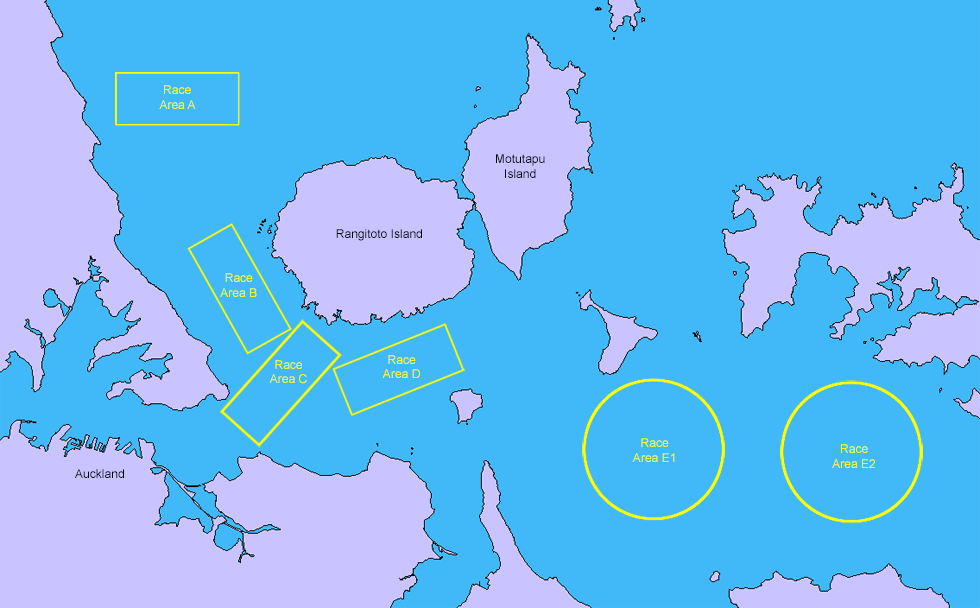
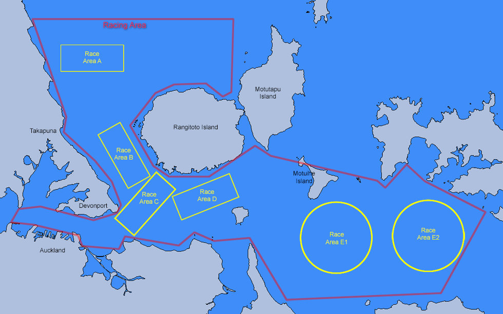
The Course Areas labeled above are designations used by the Race Director, who may select the approriate area race by race depending on sailing conditions. The rectangular courses show typical orientations, though a course may be set and modified as wind speed and direction shift. The Race Area for a given race does not need to be within these specific outlines.

The choice of Course Area is announced by the Race Director by 10:00am on the morning of the race, subject to change as needed. The specific geometric configurations, such as precise orientation, length, and number of legs of the Race Course are announced just prior to the beginning of the race.

Areas A, B, C, D above are in Course Area 1, which are the preferred locations. Within that, Race Director Iain Murray has declared that for the Prada Cup Semi-Finals and Final when possible the general region of Race Areas C and D will be used.

When the wind is lighter, and especially when it is light and from the NE, Race Area A is often the choice, to avoid the interference of Rangitoto and other land features.

Areas E1 and E2 are in the Protected Area, which may provide more shelter when seas and wind are heavier.

The Race Areas and Course Areas for the 2021 America's Cup and the Prada Cup were set by the Defender and Challenger of Record, announced in August 30, 2018, in COR/D Notice to Competitors 7.


Courses


Within Course Area 1:
Course Area A: "North Course"
Course Area B
Course Area C
Course Area D


Within Course Area 2 (The Protected Area):
Course Area E1
Course Area E2

The Race Courses are set within the overall "Racing Area" also named in the COR/D 7 announcement. The area west of Motuihe Island is designated Course Area 1. The area east of Motuihe, designated Course Area 2, offers some protection for racing when conditions are rough. Course Areas 1 and 2 overlap slightly.
 

A closer look:

Courses


Auckland Harbor
Image: New Zealand Hydrographic Authority under Creative Commons Attribution 4.0 license

Please don't use charts for on-the-water navigation unless approved for the purpose.

If you are going to attend the event in your own boat, visit the official America's Cup website for rules, regulations, and additional operator guidance. There are special restriction within the harbor and near the course area on race days, with daily updates and online resources to keep you informed of changes.


For reference to the race areas, detailed Nautical Charts are available to browse online. These are helpful in showing depth soundsings and other features that may influecne racing conditions.

See WetMaps.co.nz

North Head, the volcanic headland on the southeastern side of the Devonport peninsula impacts racing courses in a couple of ways. Between North Head and Bastion Point, more or less to the South, there is a median 2 knot tidal flow which is significant if there is wind against tide — more if there is a king tide of 3.0 metres or more. Also, note that tidal current varies across the harbour here, the current at the shallower side near North Head can be skewed in direction rounding the point, and faster than in the middle of the shipping channel.

North Head at 64 metres high (and to a lesser extent, Mount Victoria directly west at 80 metres high) tends to force the breeze either side, so there can be quite localised shifts here (and the odd hole in the wind).

The main shipping channel is dredged to around 12 metres, but there is a depression in the sea floor up to 27 metres just to the west of Bean Rock, which was probably a small lake or caldera in ancient times. The southern boundary often sees a small bulge or salient to accommodate Bean Rock – there are a few Auckland sailors who have struck, despite being well-marked, near the distinctive Kauri Cottage lighthouse (the last existing of its kind).

At the Rangitoto end, the helm should avoid straying toward the NW or SE of the gates, respectively. Outside of the race area boundary in these two directions relatively shallow beneath the surface are unforgiving basalt reefs that are remnants of the lava flows that built the island’s symmetric cone.

Back during the ice age, the inner Waitemata Harbour was once a valley with a tidal stream inbetween volcanic cones forming the hills. When sea levels rose, the harbour as we know it today flooded the valley, hence the narrow inner harbour. Relatively recently in geological perspective, volcanic Rangitoto emerged from the silty sea floor off the North Shore about 600 years ago, probably in a series of eruptions lasting only 5-10 years. The shield volcanic cone is separated from the mainland of the North Shore by the Rangitoto Channel to the east, and, along with the non-volcanic Motutapu Island, acts as the eastern land protection for vessels entering the harbour.


CupInfo Home

Inquiries please contact: